


Our hearts go out to the communities across the West currently affected by uncontrollable wildfire. With more than 96 large fires burning in 14 states and many more across Canada, it appears we are on track for yet another challenging year—though it’s difficult to imagine the possibility of a fire season any more devastating than last year’s.
Many of us remember all too well the morning of August 16, 2020, as communities across Northern California awoke to a maelstrom of lightning (and very little rain) that sparked hundreds of small fires across the region. And we braced ourselves as many of these smaller fires merged, rapidly growing into some of the largest and most destructive wildfires in state history.
The anniversary of these ignitions is approaching and it’s painful for many of us. We watched with dread and anxiety as friends and families lost homes and livelihoods, and places we’ve known and loved for so long disappeared in the flames. Here in the Santa Cruz Mountains, the CZU Lightning Complex Fire (CZU Fire) scorched 86,509 acres (over 125 square miles) and burned through the entirety of our nearly 9,000-acre San Vicente Redwoods (SVR) property.
The CZU Lightning Complex was one of the most destructive fires in state history as well as the largest fire in recorded history for the Santa Cruz Mountains.
Since protecting SVR in 2011, we’ve been working hard with our partners on habitat restoration and sustainable forestry to increase resilience to fire and climate change. This work took the form of careful forest thinning, invasive species removal, creek restoration and prescribed fire. But the simple truth is that when lightning struck a year ago, we weren’t sure this forest was ready.
So here we are, nearly one year later. Today, we’re able to look back at the fire with the clarity afforded by time, study, long conversations with colleagues and informed reflection. In many ways we’re still recovering and learning from this disaster but, at least here at POST, we’re back on our feet and pushing forward. Here are a few key lessons we’ve learned about land management from this wildfire, our observations over the last 12 months and some thoughts on where we go from here:

Shaded fuel breaks (pictured here pre-fire) are areas in a forest where brush and natural debris have been removed so that fires have less fuel to burn and can be more easily contained by firefighters.
Shaded fuel breaks work.
A shaded fuel break is created by clearing excess fuel from the forest floor and retaining a healthy canopy (as shown above). These fuel breaks provide a foothold where firefighters can work to contain a fire. Since acquiring SVR, we have partnered with the Bonny Doon Fire Safe Council to create shaded fuel breaks along key roads within this forest. We now see evidence that the fuel breaks at SVR reduced the fire’s intensity and helped slow its spread, further evidence that this technique can be tremendously effective in helping to protect life and property.
We are now in the process of investing more heavily in shaded fuel breaks across SVR, expanding buffers along key roads and creating new shaded fuel breaks along prominent ridgelines. By doing so, we hope to create more opportunities to quickly contain and suppress wildfires on this landscape in the future, while also while also creating several smaller “burn units” that lay the groundwork for future prescribed burns.
POST and our partners recently secured $3 million in state funding (in addition to $290 thousand from CAL FIRE) to expand the shaded fuel break along the entirety of Warrenella Road, a roughly ten-mile long road that connects the crest of the range with the coast. Expanding this fuel break to 400 feet (200 feet on either side of the road) will create one of the best holding-lines in the region to stop the spread of fire.
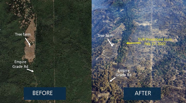
Prescribed fires work.
In February of 2020, we partnered with CAL FIRE to conduct a 25-acre prescribed burn within SVR along Empire Grade Road, one of the main thoroughfares near Bonny Doon. Little did we know that in the following summer, the CZU Fire would consume all of the surrounding landscape.
Today, it’s remarkable to see the impact of this 25-acre prescribed burn. It’s an island of green with a healthy forest canopy in the midst of a sea of scorched trees devastated by much more intense fire. The prescribed fire, which burned through the understory at low intensity, removed excess fuels from the forest floor so that the CZU Fire in this area was unable to climb into the canopy and spread from tree top to tree top.
The 2020 prescribed fire at SVR was not the first one conducted by POST and partners there, and it won’t be the last. The significant role that prescribed burns can play in managing forests is very clear, and many land managers and community members worldwide have come to understand that — it’s one of the silver linings from last year’s devastation. Indigenous Californians used fire to manage these lands for thousands of years; these landscapes are well adapted to fire and it is exciting to begin returning this essential resource management tool and practice to the land.
More than a pretty postcard, we see San Vicente Redwoods as a living landscape and one in need of careful attention, management and care.
How the fire burns matters.
How intensely a fire burns is as important as how much it burns. Hotter, more intense fires often consume the forest’s canopy while scouring its vital soils, leaving the land vulnerable to erosion and primed for invasive species to take hold. Lighter burns, however, can be beneficial in much the same way as prescribed burns, consuming fuels on the forest floor, stimulating the seedbank and adding rich soil nutrients.
While much of the CZU Fire burned at a high intensity that consumed the forest canopy and left soils exposed to the brunt of winter rains, the SVR landscape experienced a range of fire severities, giving us ample opportunities to learn more. While it’s painful to see parts of the land so vulnerable, we continue to look for opportunities to adapt and advance our work, like the planting of carbon-mitigating redwood trees and habitat-enhancing Douglas fir.
Time-lapse footage captured over the last year within the CZU Fire burn area helps to illuminate the resilience of this fire-adapted landscape and the hopeful recovery already underway. Footage courtesy of Ian Bornarth
The forest is recovering, but more fire too soon could be catastrophic.
As you can see from the footage above, the forest has been gradually recovering over the last year. It’s exciting to watch this emergence and transformation, the beginning of a new era for SVR. And while it’s true that our redwood forests are resilient, as has been the refrain by many this past year, there is a limit to fire tolerance. A redwood forest that burns too hot or too often will see more trees die, experiencing species loss and ultimately a crippling of its ecosystem.
While the CZU Fire killed many trees on SVR and beyond, it didn’t burn them completely, leaving many dead trees standing across the landscape. And this, combined with the resurgence of understory growth (as seen above), provides the makings of a dangerous mix of ingredients: future fuels building under a forest of mostly dead trees
So, though it’s difficult to hear, the risk of more catastrophic fire remains across the CZU Fire’s burn area — another reason why we feel great urgency in our efforts to make our forests more resilient before the next fire.
Hear from Nadia Hamey, the lead forester at San Vicente Redwoods, and learn how we’re finding new opportunity across this landscape.
It’s time to act, and we can’t do it alone.
We have a responsibility as managers of this forest to prepare for the inevitability of the next fire. We’ve learned so much from the effects of the CZU Fire and we know what we need to do: expand our shaded fuel breaks, conduct more prescribed burns, carry out careful forest thinning, restore creeks, maintain roads and more. It’s an “all of the above” type situation, and there’s no time to lose.
Our land stewardship work in SVR makes all the difference, and there’s no time to rest — we have to keep going.
And we can’t do it alone. The CZU Fire burned across a landscape owned and managed by a mosaic of public agencies, conservation nonprofits, academic institutions, timber companies, tribal groups, water agencies and local governments. Through the Santa Cruz Mountain Stewardship Network, a region-wide collaborative of land managers, we’re working together as we learn from this fire and this forest so that we can foster a more resilient landscape both here and across the entire region.
It’s impossible to overstate the importance of protecting and caring for this landscape, the ancestral homeland of Indigenous communities, a key life-support system for our regional ecosystems and the home of long-lived redwoods, one of our greatest assets in the fight against climate change.
To support this critical work, POST has launched the Wildfire Recovery & Resilience Fund. Donations will fund recovery needs on our San Vicente Redwoods property, support regional forest recovery efforts in the Santa Cruz Mountains, and help to improve the resilience of our local forests. Please join the fight.
Partners Make it Possible:
One of the definitive aspects of managing San Vicente Redwoods is that of partnership. POST co-owns the property with Sempervirens Fund. We actively manage the property in collaboration with Save the Redwoods League. We are planning for public access with the Land Trust of Santa Cruz County.
More Stories
About Post
Peninsula Open Space Trust (POST) protects open space on the Peninsula and in the South Bay for the benefit of all. Since its founding in 1977, POST has been responsible for saving more than 87,000 acres as permanently protected land in San Mateo, Santa Clara and Santa Cruz counties. Learn more