


This week marks an exciting development. On Saturday, December 3, San Vicente Redwoods — a property near and dear to POST — is opening its trails to the public. Once hikers, mountain bikers and equestrians register for passes, they can get a lay of a landscape that, in our humble opinion, is magnificent and fascinating to observe. And, if all goes well, we foresee many more trails to come! These 7.3 miles are the first phase of an envisioned 38-mile multi-use trail system, with construction and public access management led by the Land Trust of Santa Cruz County (LTSCC). We are proud to be among the four private, donor-funded organizations who share responsibility for protecting and caring for these lands. In addition to LTSCC, our partners include Save the Redwoods League and Sempervirens Fund.

A MULTIFACETED SETTING
San Vicente Redwoods is more than just a stunning landscape in which you can break a sweat. For one, you’re meandering through the site of a visionary conservation project. You’re also catching a rare glimpse into a forest in active recovery from recent wildfire and former clearcutting.
Be forewarned, while the property is still super resplendent, the trail system wanders through an oak woodland with other broadleaf tree species in different stages of post-fire recovery! You may not even see a redwood tree during your visit, as they dominate the forest in other parts of the property. Owing to spotty tree cover over the trails, we recommend toting a hat and some sunscreen.
As you’ll soon find: it’s an enthralling atmosphere to take in, especially if you know what to look for. Allow us to direct your attention to some enticing details!
FIVE INTRIGUING ASPECTS TO LOOK OUT FOR
Fire Following Plants

Did you know that some plants germinate after a blaze? Since the CZU fire in 2020, biologists have spied several rare plants in Santa Cruz County. Their seeds can lay dormant in the soil for up to a decade, awaiting their time to unfurl. As you hike the premises, you’ll see more eye catching and common fire following plants like yerba santa. This aromatic shrub features oblong leathery leaves and trumpet-shaped purple flowers. An occasional food source for wildlife, yerba santa has medicinal properties. Used as a treatment for asthma, it is a key ingredient in poultices to treat bites and sores. (A friendly reminder: all of the plants, animals and fungi on the trails are protected — so don’t take them home with you!)
Trail Cams

The cameras you see on the trails aren’t a new development, nor are they there to keep a watchful eye on park visitors. Instead, they are a part of ongoing years-long studies that aim to catch glimpses of wildlife. Among the topics that researchers are digging into: how different species respond when humans are on trails nearby. The cameras have spotted an array of animals, from solitary skunks and bobcat kittens to populous coveys of quail! Don’t worry too much about crowding these critters. San Vicente Redwoods links more than 27,000 acres of protected lands, making it a key passageway with plenty of room to roam around. What’s more: the trail network avoids core habitat for larger species so they can avoid any disturbances by people.
Habitat Trees

The large charred trees — or “snags” — that you see along the trails might at first seem a tad out of place. Turns out they’re crucial to our ecosystem! Despite their crispy exteriors, these sentinels are teeming with life. Many species of birds, mammals and reptiles nest and store food in their cavities. Other animals feast on forest pests that help breakdown dead trees. Snags offer perches for raptors on the hunt and serve as ideal settings for songbirds to link up with mates. We’d be remiss to leave out the fascinating fungi — mold, mildew and mushrooms — that thrive on decay.
Just outside the trail corridor, dead or damaged trees are continuing to break down. Their logs provide great habitat for moisture loving reptiles and amphibians, and will ultimately replenish the forest soil. For safety reasons, it’s important to note that their falling limbs pose risks to any hikers who’ve gone astray! That’s why it’s critical that you stay on the route as you explore the new trail system.
Trail Names in the Awaswas Language
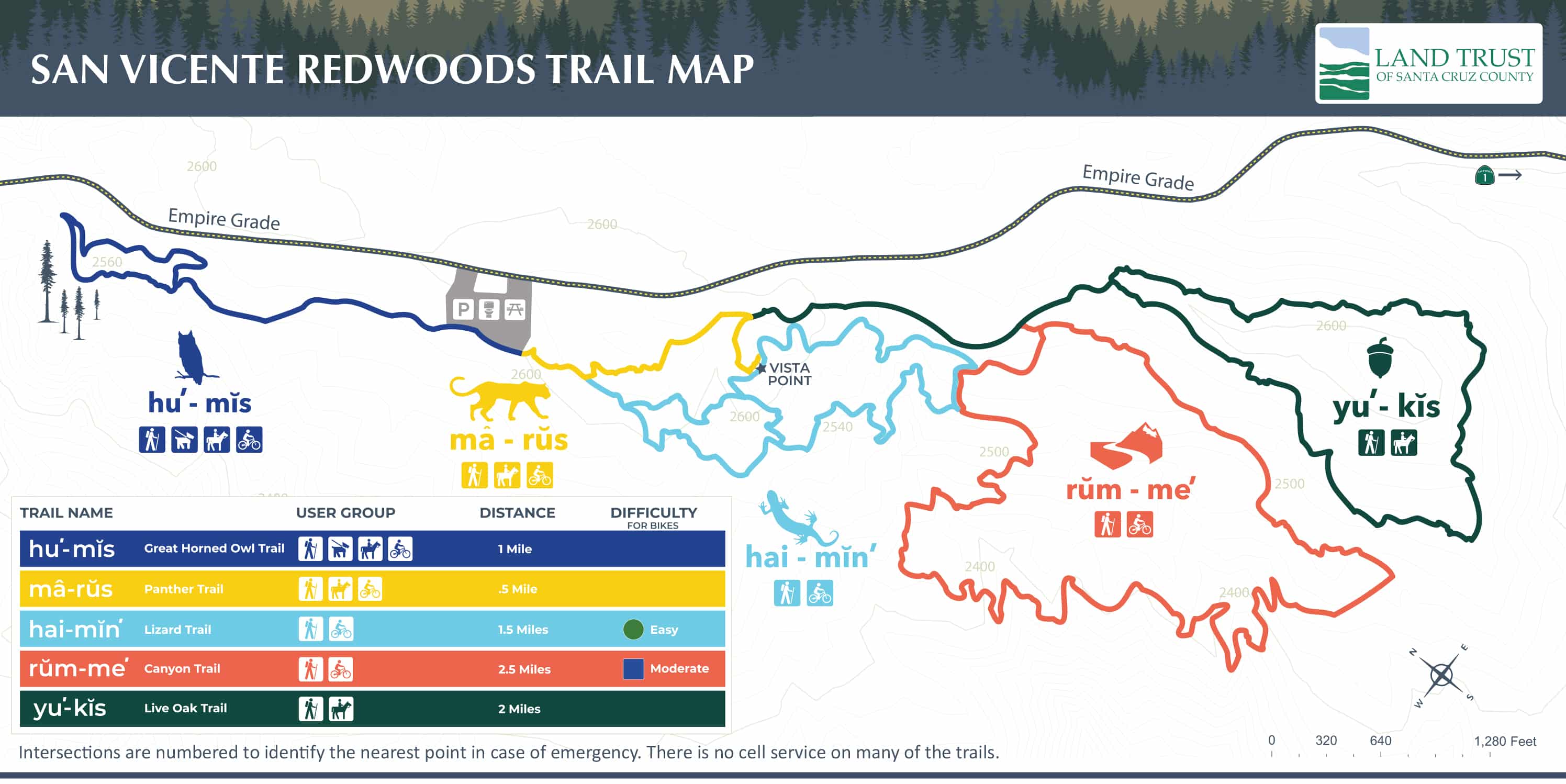
To recognize the people who inhabited and stewarded these lands for millennia, the names of the five trails are in the Awaswas language. One trail is mȃ-rŭs (panther), for example, and another is hai-min’ (lizard). The Amah Mutsun Tribal Band are among the groups collaborating to care for this landscape. “It’s important to the Amah Mutsun to ensure the Awaswas ancestors are honored and never forgotten,” said tribal band chair, Valentin Lopez, in a recent news article. For tribal members, this work is not only good land stewardship, it’s a way of reconnecting with what indigenous communities have lost. Chairman Lopez says, “It is still our responsibility to protect and steward this forest.”
A Big Green Forest Management Machine

Keeping the forest healthy is a complex undertaking. It relies on multiple strategies carried out by a host of collaborators, all working toward shared goals. Together, we aim to protect nearby communities in fire-prone areas and make the forest more resilient to climate change. Keep this in mind if you spot what looks like a ginormous bright green shipping container (more formally called an air curtain burner) on the premises. This is the innovative forest management machine we use to incinerate the debris that accrues when we pare down dry vegetation in the understory or dispose of dead and hazardous trees. The air curtain blowing across the box helps trap some emissions and protect air quality.
MAKE MEANINGFUL CHOICES
Our partners at LTSCC have designed these trails so that nature and people can thrive here, together. When you visit, please observe the rules and stay on designated trails. Your cooperation ensures that new trails will open in the future and provide you with even more inspiring places to visit and explore.
- All visitors must register and carry a pass. Passes may be revoked at any time.
- Visitors must stay on trails — no off-trail use allowed.
- Dogs must be on a leash at all times and remain on the designated dog trails only.
- Cyclists must ride in a safe manner on designated-use trails and yield to pedestrians and horses.
- All plants, animals and fungi are protected – no collecting please.
- No motor vehicles or e-bikes allowed on trails.
- No camping, hunting or firearms allowed.
- No open flames or smoking.
- No drones allowed.
- Picnic only in designated areas. Keep the forest crumb clean!
- Specific trails may be closed occasionally for your safety. LTSCC will notify pass holders about these temporary trail impacts so you can plan your visit accordingly.
Read More
About Post
Peninsula Open Space Trust (POST) protects open space on the Peninsula and in the South Bay for the benefit of all. Since its founding in 1977, POST has been responsible for saving more than 87,000 acres as permanently protected land in San Mateo, Santa Clara and Santa Cruz counties. Learn more